
leventhalmapcenter
タグをコピペすると、ブログなどにカンタン貼り付けできます。
各画像のライセンスに従って利用してください。被写体の肖像権、商標・意匠登録等にご注意ください。
詳しくはクリエイティブ・コモンズ・ライセンスの利用についてをご覧ください。

A new and general map of the Southern dominions belonging to the United States of America, viz North Carolina, South Carolina, and Georgia, with the bordering Indian countries, and the Spanish possessions of Louisiana and Florida
by Norman B. Leventhal Map Center at the BPL
by Norman B. Leventhal Map Center at the BPL

A map of those countries in which the Apostles travelled in propagating Christianity.
by Norman B. Leventhal Map Center at the BPL
by Norman B. Leventhal Map Center at the BPL

Minots Ledge off Boston Harbor, showing the proposed site of a light house
by Norman B. Leventhal Map Center at the BPL
by Norman B. Leventhal Map Center at the BPL

A map of the North Pole with all the territories that lye near it, known to us &c. According to the latest discoveries, and most exact observations
by Norman B. Leventhal Map Center at the BPL
by Norman B. Leventhal Map Center at the BPL

Hammond's new road map of Rhode Island and southeastern Massachusetts
by Norman B. Leventhal Map Center at the BPL
by Norman B. Leventhal Map Center at the BPL

A map of the city of Boston in Massachusetts
by Norman B. Leventhal Map Center at the BPL
by Norman B. Leventhal Map Center at the BPL

Plan of Dorchester Bay showing its surroundings together with current observations to illustrate the effect of discharging sewage at cow pasture point
by Norman B. Leventhal Map Center at the BPL
by Norman B. Leventhal Map Center at the BPL

Map of the environs of Boston /
by Norman B. Leventhal Map Center at the BPL
by Norman B. Leventhal Map Center at the BPL

A new map of the Province of Quebec
by Norman B. Leventhal Map Center at the BPL
by Norman B. Leventhal Map Center at the BPL

Pascaert vande Caribes Eylanden
by Norman B. Leventhal Map Center at the BPL
by Norman B. Leventhal Map Center at the BPL

A chart of the coast of New England from the south shoal to Cape Sable including Georges Bank
by Norman B. Leventhal Map Center at the BPL
by Norman B. Leventhal Map Center at the BPL

A new and accurate chart of the Bay of Chesapeak including Delaware Bay
by Norman B. Leventhal Map Center at the BPL
by Norman B. Leventhal Map Center at the BPL


Panorama de Mexico a puebla, con todos los caminos, rios, poblaciones y montes
by Norman B. Leventhal Map Center at the BPL
by Norman B. Leventhal Map Center at the BPL

From Muskeget Channel to Buzzard's Bay and entrance to Vineyard Sound, Mass.
by Norman B. Leventhal Map Center at the BPL
by Norman B. Leventhal Map Center at the BPL

Paskaarte van Het Zuydelijckste van America van Rio de la Plata, tot Caap de Hoorn, ende inde Zuyd Zee, tot B. de Koquimbo
by Norman B. Leventhal Map Center at the BPL
by Norman B. Leventhal Map Center at the BPL

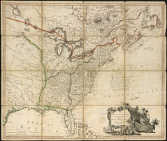
Map of the southern states of America, comprehending Maryland, Virginia, Kentucky, Territory s'th of the Ohio, North Carolina, Tennessee Governm't., South Carolina, & Georgia
by Norman B. Leventhal Map Center at the BPL
by Norman B. Leventhal Map Center at the BPL


Senones : Evesché d'Auxerre : Comté et Ballge d'Auxerre : Eslectons. de Clamecy, de Gien, de la Charité, et de Vezelay
by Norman B. Leventhal Map Center at the BPL
by Norman B. Leventhal Map Center at the BPL


An accurate map of Europe from the best authorities
by Norman B. Leventhal Map Center at the BPL
by Norman B. Leventhal Map Center at the BPL

The north part of America , conteyning Newfoundland, new England, Virginia, Florida, new Spaine, and Noua Francia wth ye rich Iles of Hispaniola, Cuba, Iamaica, and Porto Rieco on the south, and upon ye west the large and goodly Iland of California ...
by Norman B. Leventhal Map Center at the BPL
by Norman B. Leventhal Map Center at the BPL

A new chart of the sea coast from the Island of Cyenne to the River Poumaron ...
by Norman B. Leventhal Map Center at the BPL
by Norman B. Leventhal Map Center at the BPL

Preliminary plan for widening Chesnut Hill Avenue
by Norman B. Leventhal Map Center at the BPL
by Norman B. Leventhal Map Center at the BPL

![[Chart of Maldonado and the Island of Gorriti]](http://farm5.static.flickr.com/4005/4232064562_f817e9393f_m.jpg)
[Chart of Maldonado and the Island of Gorriti]
by Norman B. Leventhal Map Center at the BPL
by Norman B. Leventhal Map Center at the BPL

Brookline Water Works, source, line of supply and distribution
by Norman B. Leventhal Map Center at the BPL
by Norman B. Leventhal Map Center at the BPL
![[Chart of Tierra del Fuego and the Strait of Magellan]](http://farm3.static.flickr.com/2681/4232065180_bfc422d488_m.jpg)
[Chart of Tierra del Fuego and the Strait of Magellan]
by Norman B. Leventhal Map Center at the BPL
by Norman B. Leventhal Map Center at the BPL
![The island of Bermudos divided into its tribes, with the castles, forts &c. ; [Part of Providence Island]](http://farm5.static.flickr.com/4019/4586546091_a84ae74052_m.jpg)
The island of Bermudos divided into its tribes, with the castles, forts &c. ; [Part of Providence Island]
by Norman B. Leventhal Map Center at the BPL
by Norman B. Leventhal Map Center at the BPL

Carte de l'Amérique septentrionale, depuis la baye d'Hudson jusqu'au Mississipi: pour servir aux essais historiques et politiques sur la révolution de cette partie du monde
by Norman B. Leventhal Map Center at the BPL
by Norman B. Leventhal Map Center at the BPL

Pocket map of the city of Worcester, Mass.
by Norman B. Leventhal Map Center at the BPL
by Norman B. Leventhal Map Center at the BPL

Plan showing the principal portion of Boston, from the oldest authorities
by Norman B. Leventhal Map Center at the BPL
by Norman B. Leventhal Map Center at the BPL

Plan de Boston avec les sondes et les directions pour la navigation
by Norman B. Leventhal Map Center at the BPL
by Norman B. Leventhal Map Center at the BPL

A map of the most inhabited part of New England, containing the provinces of Massachusets Bay and New Hampshire, with the colonies of Conecticut and Rhode Island ...
by Norman B. Leventhal Map Center at the BPL
by Norman B. Leventhal Map Center at the BPL

A plan of Quebec and environs, with its defenses and the occasional entrenched camps of the French commanded by Marquis de Montcalme
by Norman B. Leventhal Map Center at the BPL
by Norman B. Leventhal Map Center at the BPL

Phelps & Ensign's travellers' guide, and map of the United States, containing the roads, distances, steam boat and canal routes &c.
by Norman B. Leventhal Map Center at the BPL
by Norman B. Leventhal Map Center at the BPL

A new, plaine & exact map of Europe, described by N.I. Visscher and done into English, enlarged & corrected according to I. Blaeu, with the habits of the people, and manner of the cheife cities, 1658, the like never before
by Norman B. Leventhal Map Center at the BPL
by Norman B. Leventhal Map Center at the BPL

Plan de la Riviere de Seine dans Paris
by Norman B. Leventhal Map Center at the BPL
by Norman B. Leventhal Map Center at the BPL

A plan of the town dock, formerly called Bendalls Dock, in Boston, with the buildings round & flats before it
by Norman B. Leventhal Map Center at the BPL
by Norman B. Leventhal Map Center at the BPL

A map of the Yearly Meeting of Friends for New England
by Norman B. Leventhal Map Center at the BPL
by Norman B. Leventhal Map Center at the BPL

An authentic plan of the River St. Laurence, from Sillery to the Fall of Montmerenci, with the operations of the Siege of Quebec, under the command of Vice-Adml. Saunders & Majr. Genl. Wolfe, down to the 5 Sepr. 1759
by Norman B. Leventhal Map Center at the BPL
by Norman B. Leventhal Map Center at the BPL

A map of the Dutch settlements of Surinam, Demerary, Issequibo, Berbices, and the islands of Curassoa, Aruba, Bonaire, &c., with the French colony of Cayenne, and the adjacent Spanish countries, taken from a map executed under the patronage of the ...
by Norman B. Leventhal Map Center at the BPL
by Norman B. Leventhal Map Center at the BPL

Exact plan of General Gage's lines on Boston Neck in America
by Norman B. Leventhal Map Center at the BPL
by Norman B. Leventhal Map Center at the BPL

An actual survey of the sea coast from New York to the I. Cape Brition
by Norman B. Leventhal Map Center at the BPL
by Norman B. Leventhal Map Center at the BPL


Pascaerte van Westindien de Vaste Kusten en de Eylanden
by Norman B. Leventhal Map Center at the BPL
by Norman B. Leventhal Map Center at the BPL

The seat of war in the circle of Westphalia
by Norman B. Leventhal Map Center at the BPL
by Norman B. Leventhal Map Center at the BPL

A map of the extremity of Cape Cod
by Norman B. Leventhal Map Center at the BPL
by Norman B. Leventhal Map Center at the BPL

Plan of Chesnut Hill, in Brookline & Newton
by Norman B. Leventhal Map Center at the BPL
by Norman B. Leventhal Map Center at the BPL

A new and correct plan of the town of Boston
by Norman B. Leventhal Map Center at the BPL
by Norman B. Leventhal Map Center at the BPL

National Highways map of the state of Massachusetts showing one thousand miles of national highways proposed by the National Highways Association, Washington D.C.
by Norman B. Leventhal Map Center at the BPL
by Norman B. Leventhal Map Center at the BPL
The United States of North America: with the British territories and those of Spain according to the treaty of 1784
by Norman B. Leventhal Map Center at the BPL
by Norman B. Leventhal Map Center at the BPL

Preliminary plan for widening Beacon Street from the Back Bay district of Boston to the public pleasure ground at Chestnut Hill Reservoir and for connections with Massachusetts and Commonwealth Avenues
by Norman B. Leventhal Map Center at the BPL
by Norman B. Leventhal Map Center at the BPL

Map of the metropolitan district of Boston, Massachusetts, showing local public reservations and holdings of the Metropolitan Park Commission
by Norman B. Leventhal Map Center at the BPL
by Norman B. Leventhal Map Center at the BPL

Boston Subway, East Boston Tunnel, Washington St. Tunnel, tunnel for Cambridge connection & proposed Riverbank Subway
by Norman B. Leventhal Map Center at the BPL
by Norman B. Leventhal Map Center at the BPL


A chart of the Island of Cape Breton
by Norman B. Leventhal Map Center at the BPL
by Norman B. Leventhal Map Center at the BPL

Birds eye view of the White Mountains
by Norman B. Leventhal Map Center at the BPL
by Norman B. Leventhal Map Center at the BPL

A map of the countries thirty degrees round the north pole
by Norman B. Leventhal Map Center at the BPL
by Norman B. Leventhal Map Center at the BPL
241件~300件 (全 2,130件)