
Oil Slick in the Gulf of Mexico June 19, 2010 : 無料・フリー素材/写真
Oil Slick in the Gulf of Mexico June 19, 2010 / NASA Goddard Photo and Video
| ライセンス | クリエイティブ・コモンズ 表示 2.1 |
|---|---|
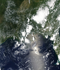
| 説明 | NASA image acquired June 19, 2010To see a close up detail of this image go to: www.flickr.com/photos/gsfc/4721299117On Saturday, June 19, 2010, oil spread northeast from the leaking Deepwater Horizon well in the Gulf of Mexico. The oil appears as a maze of silvery-gray ribbons in this photo-like image from the Moderate Resolution Imaging Spectroradiometer (MODIS) on NASA’s Terra satellite.The location of the leaking well is marked with a white dot. North of the well, a spot of black may be smoke; reports from the National Oceanic and Atmospheric Administration say that oil and gas continue to be captured and burned as part of the emergency response efforts.The large image provided above is at MODIS’ maximum spatial resolution (level of detail). Twice-daily images of the Gulf of Mexico are available from the MODIS Rapid Response Team in additional resolutions and formats, including a georeferenced version that can be used in Google Earth.NASA image courtesy the MODIS Rapid Response Team. Caption by Rebecca Lindsey. earthobservatory.nasa.gov/Instrument: Terra - MODISNASA/GSFC/Jeff Schmaltz/MODIS Land Rapid Response TeamNASA Goddard Space Flight Center is home to the nation's largest organization of combined scientists, engineers and technologists that build spacecraft, instruments and new technology to study the Earth, the sun, our solar system, and the universe. |
| 撮影日 | 2010-06-19 14:41:22 |
| 撮影者 | NASA Goddard Photo and Video , Greenbelt, MD, USA |
| タグ | |
| 撮影地 |