
Map of Manitoba Showing Vegetative Belts (1934) : 無料・フリー素材/写真
Map of Manitoba Showing Vegetative Belts (1934) / Historical Maps of Manitoba
| ライセンス | クリエイティブ・コモンズ 表示 2.1 |
|---|---|
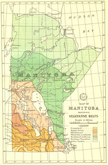
| 説明 | Robert Bell and Ernest Thompson Seton showed some of the basic vegetation distribution patterns within Manitoba on their maps. Professional foresters integrated data of this sort and produced general distribution maps of vegetation such as appeared, for example, in the 1906 edition of the Atlas of Canada. In 1934 the first pamphlet on forests of Manitoba was published, containing the map shown here. It shows the great variation in vegetation in Manitoba: from grassland, to deciduous and boreal forests, to arctic tundra. By 1934 the forest resources of Manitoba were being used for pulp and paper manufacture, as well as sawmilling.(Warkentin and Ruggles. Historical Atlas of Manitoba. map 237, p. 456)--------------Map of Manitoba Showing Vegetative Belts. 1934. Scale 1 inch to 114 miles. Printed in J.D.B. Harrison. The Forests of Manitoba. Canada Department of the Interior, Forest Service Bulletin 85. Ottawa 1934. Facing 19. |
| 撮影日 | 2008-01-18 12:11:40 |
| 撮影者 | Historical Maps of Manitoba , Canada |
| タグ | |
| 撮影地 |